The University of Arizona is quietly facilitating construction of the proposed Copper World Mining Complex by green lighting utility rights of way (ROW) across the 53,000-acre Santa Rita Experimental Range, state records show.
The Range is owned by the Arizona State Land Department and managed by the University of Arizona’s College of Agriculture and Life Sciences. The U.S. Forest Service transferred the Range to the state in 1988. State statute requires the Range to be operated for “ecological and rangeland research purposes.” (See page 208-209.)
Since at least 2009, University of Arizona officials have given affirmative written approval or remained officially silent on requests by two Canadian mining companies seeking ROWs across the Range. Without the ROWs, the project’s current owner, Toronto-based Hudbay Minerals Inc., would face enormous challenges in developing its planned $1.3 billion Copper World project.
“It’s outrageous that a handful of University of Arizona bureaucrats are facilitating the construction of at least four open-pit copper mines that will destroy the northern half of the Santa Rita Mountains,” says Dr. Rob Peters, executive director of Save the Scenic Santa Ritas, a Tucson-based conservation group that has opposed mining in the mountains for decades. “This is an unnecessary project that is opposed by Pima County, the City of Tucson, three Indian Tribes, thousands of area residents, and environmental groups across the region, state and country.”
State regulations allow the land department to accept or reject the university’s recommendation to approve or deny a ROW application across the Range. But given the history and ecological importance of the Range, the university’s recommendation is a crucial factor.
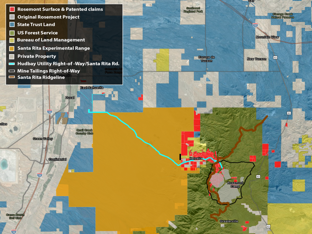
In 2017, the land department issued ROWs that allow construction of an underground water pipeline and high-voltage power lines across 11 miles of the Range running parallel to the Santa Rita Road. In January 2023, the land department approved a ROW across a separate section of the Range for pipelines capable of transporting toxic mining waste called tailings, an additional high voltage power line, communications line and an access road. None of the infrastructure has been installed.
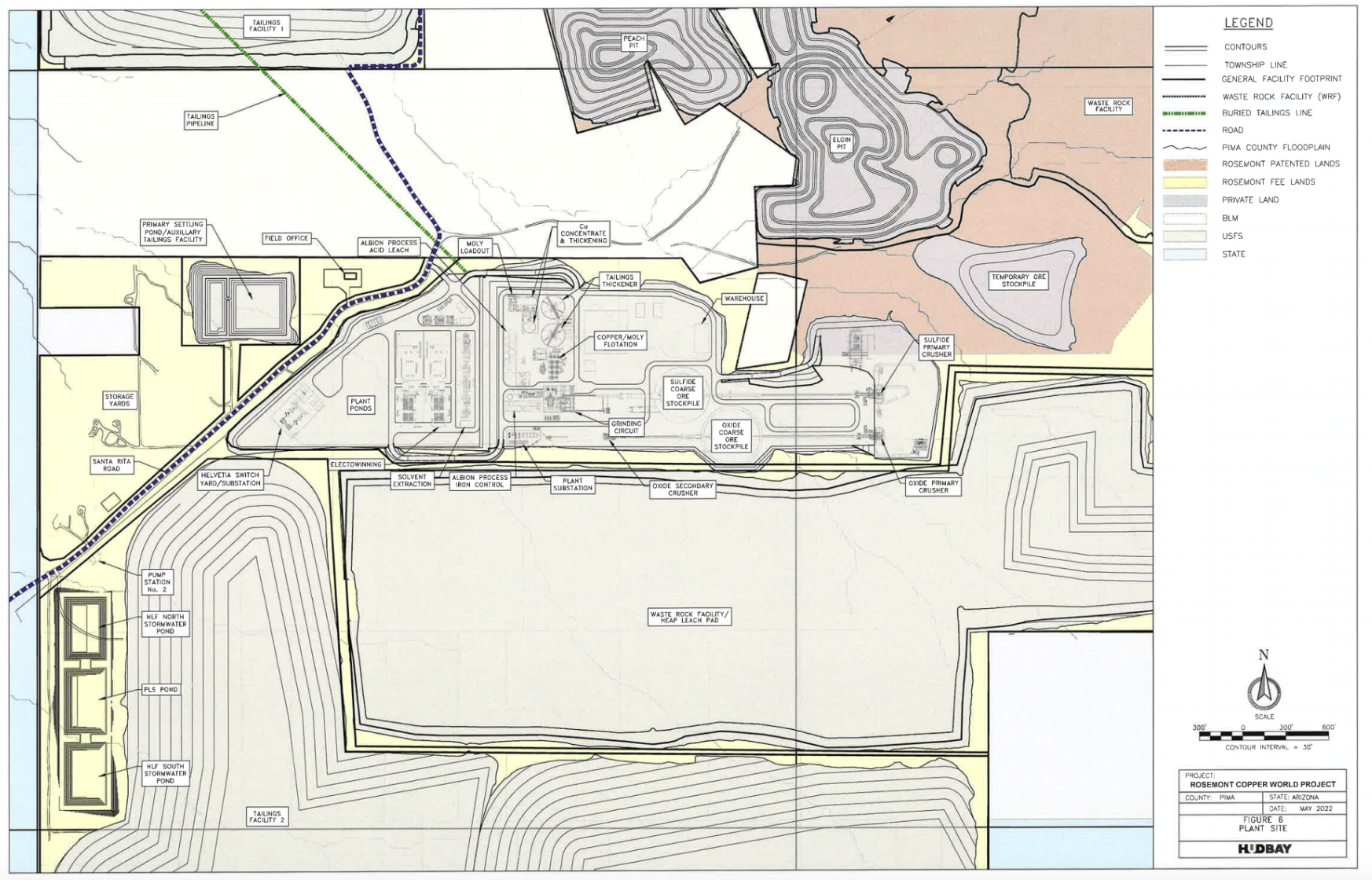
The latest ROW would allow Hudbay to transport hundreds of millions of tons of mine tailings to waste dumps that will tower hundreds of feet high and abut several miles of the Range’s eastern border. Copper tailings can contain arsenic, lead, cadmium, and uranium among other metals. There is concern blowing dust from the waste dumps could impair ongoing research on the Range and impact a nearby housing development and elementary school. (See studies here, here and here.)
Mine tailings also pose a threat to groundwater aquifers. Copper mines have frequently polluted groundwater aquifers in Arizona, according to a 2012 report prepared by Earthworks, a Washington, D.C. environmental group that monitors hard rock mining. “Our research shows that water quality impacts to surface and/or groundwater are common at currently operating copper porphyry mines in U.S.,” the Earthworks’ report concluded.
Established in 1902, the Santa Rita Experimental Range “is one of the longest-running ecological experimental sites in the world and an area where some of the most important theories of ecological succession were developed in the early 20th Century,” Pima County Development Services stated in a 2012 letter to the land department opposing utility ROWs through the Range.
“This rich ecological history and the ongoing experiments have provided invaluable information that has aided our understanding and management of rangelands throughout the southwest United States and beyond,” Pima County stated.
The Range is currently a key component in the National Ecological Observatory Network. NEON is a continental-scale observation facility designed to collect long-term open access ecological data to better understand how U.S. ecosystems are changing. The Range is the core terrestrial field site in the desert Southwest.
The Range is also a “significant cultural landscape” for several Native American Tribes. The Range includes Huerfano Butte, a Tohono O’odham sacred site. The 2017 ROW corridor with overhead high voltage power lines passes just north of Huerfano Butte.
“Visual effects of the proposed undertaking should be considered,” the county stated in 2012.
University provided no written response to Hudbay’s 2022 ROW application
The most recent ROW reveals the high-stakes decisions that are quietly being made by University of Arizona officials. In early 2022, Hudbay was facing a major obstacle in its latest mining plan. The company’s previous mining plan called for dumping waste rock and mine tailings on 2,500 acres of the Coronado National Forest on the east side of the Santa Rita Mountains. But this plan was blocked by a 2019 federal court ruling that was subsequently upheld on appeal in 2022.
Hudbay then shifted its focus to operating only on private land on both sides of the Santa Rita Mountains. The new plan dramatically increased the impact on the Santa Rita Experimental Range because Hudbay shifted mine processing operations from the east side of the mountain to the west side. The only access to Copper World’s mine processing facility would be across the unpaved Santa Rita Road that bisects 11 miles of the Santa Rita Experimental Range.
The new location also greatly complicated Hudbay’s mining plan because the company needed to find a way to move hundreds of millions of tons of mine tailings from its copper ore processing facilities to mine tailings dumps located on nonadjacent private land. U.S. Bureau of Land Management (BLM) property is between the mine processing plant and the tailings dump sites.
Hudbay initially said it would install an underground tailings pipeline across the BLM property. But crossing BLM land was risky because it would have triggered environmental reviews under the federal National Environmental Policy Act.
Instead, in April 2022, Hudbay applied to the state land department for a ROW through the Range. The ROW would connect Hudbay’s processing facilities with the waste dumps and avoid the BLM property. The ROW would also not be subject to environmental review.
Hudbay’s ROW application requested a 150-foot wide, 3,320-foot-long strip across the Range “for an access road, fresh water pipeline, tailings pipeline, process water return pipeline, electrical services and telecommunications line.”
In July 2022, the land department sent a letter to Bruce Vaughan, University of Arizona’s director of real estate, notifying him that Hudbay’s subsidiary, Rosemont Copper Company, which subsequently changed its name to Copper World in 2023, had applied for a ROW across the Range.
The letter stated the ROW was for an “access road, 3 pipelines, electrical and telecommunications lines.” Notably missing from the land department’s letter to the university, which was also addressed to the Board of Regents, was any reference to a “tailings pipeline”. The Board of Regents oversees the state’s three public universities.
The department’s letter offered Mr. Vaughan an opportunity to submit written comments concerning the proposed ROW. Land department regulations require that a ROW applicant (Hudbay) “furnish evidence” from the current leaseholder (University of Arizona), “giving consent of the new right-of-way or objection thereto.” There is no record in the land department’s database that the university or the Board of Regents provided a written response to the department’s letter.
The university’s failure to furnish evidence of its consent or objection to the ROW raises questions over what role former Board of Regents Chairman Fred DuVal may have played. Mr. DuVal, who resigned as Board of Regents chairman on March 1, is heavily involved in promoting copper production in Arizona and is Chairman of Excelsior Mining Corp., which operates the Gunnison Copper Project in Cochise County. In a March 2022 column published by the Arizona Republic, Mr. DuVal stated that “opportunity is knocking on Arizona’s door” to develop new copper mines and that the state “would be foolish to lock it shut.”
The Board of Regents, the University of Arizona, and the Range have each refused to comply with written public records requests submitted by Save the Scenic Santa Ritas last October for documents related to the ROW.
Mine opponents file lawsuit against state challenging ROW
Save the Scenic Santa Ritas and Farmers Investment Co., a Sahuarita pecan farming operation, filed a lawsuit in January 2024 alleging that the land department’s Board of Appeals violated the state’s Open Meeting Law when the ROW was processed and approved. The plaintiffs are asking the court to revoke the ROW if it rules there was an Open Meeting Law violation. (An Order to Show Cause hearing will be held at 10 a.m., Friday, March 22 in Maricopa County Superior Court and the public can listen by going to https://www.superiorcourt.maricopa.gov/calendar/today/ Case No. CV2024-001259.)
The lawsuit alleges the land department knew Hudbay was seeking the ROW to install tailings pipelines but hid that fact from the public when it posted the December 2022 agenda for the Board of Appeals public meeting on the ROW application.
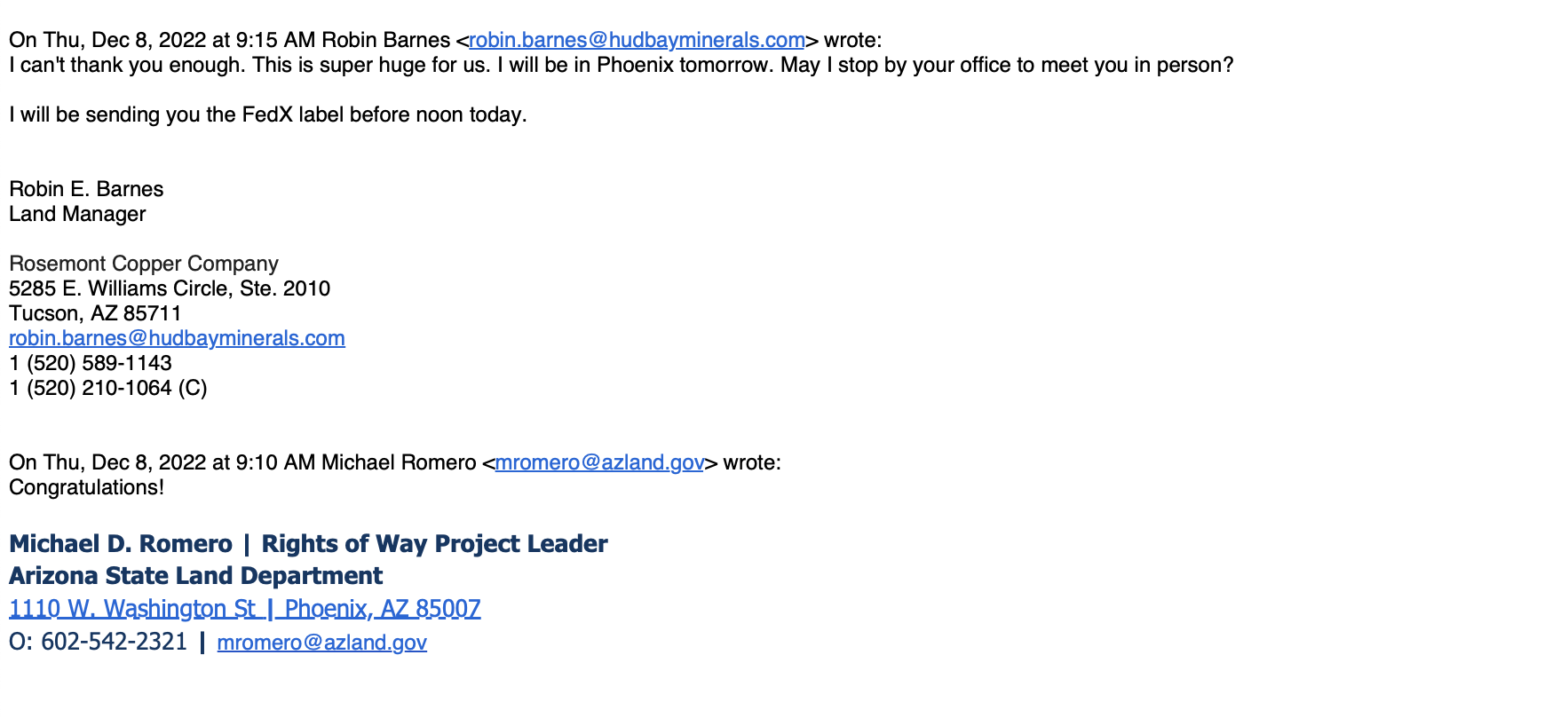
A week before the December Board of Appeals meeting, Robin Barnes, Hudbay’s land manager, sent an email to Michael Romero, the department’s right of way project leader, stating: “Our application provides for 3 above-ground pipelines and we expect to have 3 above-ground pipelines for tailings, sand, reclaimed water and other uses.”
The Board of Appeals agenda, however, only stated it was being asked to approve a ROW that included “two, 24” water pipelines” with no mention of Hudbay’s initial application that requested a tailings pipeline or reference to Ms. Barnes’s email. The Board approved the ROW on its consent agenda with no discussion.
Within minutes of the vote, a Hudbay official sent a text to the land department manager handling the ROW of application that summed up how important obtaining the ROW was to the company. “I can’t thank you enough,” Ms. Barnes stated in an email to Mr. Romero, “This is super huge for us.”
In January 2023, the land department issued the ROW to Hudbay’s subsidiary, Copper World. The ROW, which was reviewed and edited by Hudbay officials before being finalized, no longer included just two 24-inch water pipelines as stated in the December Board of Appeals meeting agenda or even the three pipelines Ms. Barnes demanded before the Board of Appeals meeting.
Instead, the ROW, at the request of Hudbay, allows for the construction of “six above ground 24” transmission lines, an access road, electrical and telecommunications lines.” (Emphasis added.)
While ROW does not explicitly state that it will include tailings pipelines, Hudbay made it clear in its April 2022 initial ROW application and subsequent discussions with the land department that it intends to construct tailings pipelines in the ROW. And, the fact that the ROW connects Copper World’s processing facilities with the mine’s primary tailings dump makes it obvious that the ROW will be used for tailings pipelines.
University officials approved ROWs adjacent to the unpaved Santa Rita Road in 2009, eight years before they are sold to Rosemont Copper
In the late 2000s, Rosemont Copper, which was then owned by Vancouver, B.C. based Augusta Resource Corp., requested two ROWs across the Range for a high voltage power line and an underground water pipeline.
On March 31, 2009, Colin Kaltenbach, vice dean and director at the College of Agriculture and Life Sciences, met with an Augusta Resource executive and the company’s attorney, and Ruben Ojeda, the land department’s right of way section manager, at the department’s Tucson office to discuss two proposed ROW alignments across the Range.
Three months later, Mr. Kaltenbach sent a June 30, 2009 letter to Mr. Ojeda stating the university “carefully considered the two proposals” and recommended an alignment along the Santa Rita Road that bisects the Range. Mr. Kaltenbach stated the university’s Range Advisory Committee and Range staff concluded the ROW alignment would not “result in any significant adverse impact to the University’s range operations.”
Mr. Kaltenbach, however, requested the land department attach several conditions to the ROWs including implementing a dust abatement program for the unpaved Santa Rita Road and provide funding for the Range to hire security staff to monitor the water and power line construction to “ensure the integrity of the Range is respected.” The ROWs that were eventually issued to Rosemont Copper do not include a dust abatement program for the Santa Rita Road or funding for hiring security staff.
In 2011, Mr. Kaltenbach sent a letter to the Arizona Corporation Commission’s Arizona Power Plant and Transmission Siting Committee concerning the location of the ROW for Rosemont Copper’s 138 kV transmission line. Kaltenbach stated the power line ROW “will not significantly change existing conditions within the Range, or adversely impact the Range facilities or its operations.”
The power line is planned to connect a substation in Sahuarita to the mine processing facilities on the western flank of the Santa Rita Mountains. The 50-year ROW was not issued until 2017 when Rosemont Copper was the only bidder at a public auction. Rosemont Copper paid $304,394 for the 110-acre ROW across the Range. ($55.34/acre/year)
Five years prior to the public auction, Pima County Development Services had sent its letter to the land department sharply critical of selling the power line ROW to Rosemont Copper.
“By granting a 50-year easement, the power line could be used for domestic, commercial or industrial consumption after the mine closes” if the Legislature decides to change the use of the Range from ecological and rangeland research to development purposes.
“Granting a long-term ROW to Rosemont Copper will very likely erode the long-term viability of the range,” Pima County’s Sept. 20, 2012 letter states. “A long term easement would not be in the interest of the State Land Department or any other agency charged with maintaining rangelands.”
Mining plans have dramatically changed since the University’s 2009 ROW assessment
When the University of Arizona made its 2009 ROW recommendations to the land department to include dust abatement for the Santa Rita Road, mining was only planned for the Rosemont pit on the east side of the Santa Rita Mountains. Access to Rosemont’s processing facilities was to be off State Route 83 between Vail and Sonoita.
That is no longer the case.
The unpaved Santa Rita Road is now planned to become the only access road to what could become the third largest open pit copper mining operation in the United States. A 2017 federal environmental report stated that the Rosemont pit alone was projected to have between 100 and 120 trucks per day driving on SR 83.
Now those trucks will be generating continuous traffic and waves of dust across the Santa Rita Experimental Range, 24 hours a day, 365 days a year. The mining trucks will be transporting millions of tons of sulfuric acid as well as copper concentrate and other mining materials.
Neither the University of Arizona nor the land department have released environmental reports – if they have even been prepared — on how Copper World’s heavy truck traffic on the Santa Rita Road will impact ongoing research on the Santa Rita Experimental Range. Nor have there been any studies on the impact of the mine tailings dumps on Range research operations.
In 2022, the university and the land department had that opportunity to study how the shift of mining operations to the west side of the Santa Rita Mountains would impact the road and the Santa Rita Experimental Range when Hudbay requested the ROW for the tailings pipelines, access road, communications line and power line.
Rather than taking action to protect the environmental integrity of the Range, the University remained silent when asked to comment on the proposed ROW. Meanwhile, land department staff prepared the agenda for the Board of Appeals crucial December 2022 meeting which failed to publicly disclose that tailings pipelines would be allowed in the ROW.
“It’s clear to me that the university and the land department are violating their legislative mandate to operate the Santa Rita Experimental Range for ecological and rangeland research purposes by improperly facilitating the construction of a mine that will clearly inflict serious damage on the Range,” said Dr. Peters from the Save the Scenic Santa Ritas conservation group. “As a result, Governor Hobbs should revoke all mining-related rights of way across the Santa Rita Experimental Range.”
Not surprising given the underhanded actions by virtually all groups that are supporting this ill-conceived mining operation. The University of Arizona’s actions would be incomprehensible but consistent with its recent administration’s actions.
I am an intervening party in the Rosemont Copper transmission line siting hearings. It was testified that “Rosemont” would not use Santa Rita Road for any mining activities and that SR 83 would be used for all Rosemont activities including haul and mining vehicles and that Rosemont employees would use company buses to and from work at that mine. Copper World shifted this traffic to Santa Rita Road, a major concept change. There would be no Rosemont activities that use the Santa Rita Experimental Range roads.
Further, the Rosemont transmission line right of way easement, granted by the Arizona Corporation Commission’s (ACC) Certification of Environmental Compatibility (CEC), would have two water pipelines, one three-phase 138kV transmission line, and a “fence”. Access to the transmission line would be from Santa Rita Road; however, there also was a “road” included to parallel this easement, for inspections and maintenance. Any fence within the Experimental Range obstructs wildlife movement and thus has a negative impact for many studies. Also, the tall utility poles have flat tops that impact small wildlife by providing perches for predator birds. In addition to other objections, the fence, road and raptor perches were included of my objections.
The water for Rosemont is planned from groundwater wells nearf the Town of Sahuarita for the purpose of washing rock tailings. It was shown that Central Arizona Project (CAP) water, available near to the proposed Rosemont groundwater wells, adequately meets this rock washing objective.
Groundwater in the Pima Active Management Area, a factor ignored by the Siting Committee (see ARS 40-360.14), is presently extracted from this AMA more than it is being replaced. The Pima AMA water table is lower every year. Using surface CAP water from the Colorado River, avoids billions of gallons of groundwater for washing rocks. This critical issue (ARS 40-360.14) was not discussed at the transmission line hearings because the Line Siting Chairman would not allow discussion of environmental impacts of the mine but only those caused by the transmission line. CAP water should be used and not local groundwater for these mines.
The “bait and switch” from Rosemont to Copper World clearly was not included in the ACC hearings or CEC decision. That ‘switch’ changed the entire mining project (minus the transmission line) from being fully on the east of the Santa Ritas to the west. The environmental impacts are significantly different between Rosemont only and Copper World mines.
The NEPA required Rosemont Environmental Impact Statement (EIS) was used by the Line Siting Committee as the basis of significant environmental impacts and the transmission line. The Rosemont EIS is not applicable for the different mines being developed by Copper World. In fact, since the Rosemont EIS is over five years old and the project hasn’t begun, as a minimum, a Supplemental EIS is required just to update the environmental effects for that mine.
In summary, a completely new EIS and ACC CEC are necessary and essential to fill the large gap between Rosemont and the new Copper World projects to access the total environmental impacts of the mine and transmission line right of way.
ARIZONA IS ALL ABOUT COPPER AND THIS GOES HAND-IN-HAND WITH THE POLITICS THAT RUN THE STATE . THE LEVEL OF MEDDLING AND INCOMPETENCE IN THIS PROJECT THAT THE GOVERNMENT HAS DISPLAYED AT ALL LEVELS IS STAGGERING . HUDBAY EXCEL AT MANIPULATION TIED TO FINANCIAL BENEFITS . THEY HAVE TIME ON THEIR SIDE AND AN ELECTION IS LOOMING .
Is there any organized response opposing this?
Is there an organized opposition which we can join?
Green Valley is comparable with Verde Valley in the central part of the state. The mines there proved devastating to the surroundings. With all the technology available today it is still a gigantic terraforming operation that will permanently disfigure and degrade the natural landscape and ecology. Claiming otherwise is disingenuous at best or an outright misrepresentation.